Online Records

The Amelia Island Genealogical Society has collected 47,000 genealogical records for individuals who have lived in Nassau County Florida.

Elmore Wilds Cemetery

Elmore Wilds Cemetery

Elmore Wilds Cemetery, also known as the Wilder Wilds Cemetery, is in Evergreen Florida. Go north on US 17 to CR 108. Turn left, proceed to first paved road on left (Sandhill Dump), turn left. There is a fork in the road at about 600 ft, Take the right fork to the locked gate. About 8/10 mile from CR 108 are two cemeteries here, Jones-Jacobs Cemetery and Elmore Wilds Cemetery. The Jones-Jacobs Cemetery data is reported separately. Traveling on CR-108 there are road signs for Elmore Wilds Cemetery. Elmore Wilds Cemetery Location (Nassau County)Evergreen, FL USA GPS Location: 30.686861, -81.724694 This cemetery was inventoried in March 1998 by Kenneth Sturges. Jim Miller photographed it in 2015. Elmore Wilds Cemetery Photographs

Elmore Wilds Cemetery Read More »

Verdie Cemetery

Verdie Cemetery is located in Bryceville, Florida. To reach it, take US301 south from Callahan for 9.3 miles. Turn left on Ford Road which is paved, but not marked. To 6/10 mile and turn left on Verdie Cemetery Road. The cemetery is 3/10 mile. It appears that you dead end into the cemetery, but the road actually veers to the right. A sign on the cemetery lists these numbers for further information: 879-3417 or 879-2175. The cemetery is enclosed in a chain link fence and is approximately 150 ft by 200 ft. This is a well maintained cemetery with oaks and cedar trees providing shade. Some benches have been installed at grave sites. The area of Nassau County known as Verdie is named for Verdie Surrency, the daughter of J. Allen Surrency. Surrency moved to the area of Nassau County then known as Dutton from Tattnall County, Georgia. He farmed his land and provided wood for the railroad. In 1895, the post office at Dutton was discontinued and Surrency was named the new postmaster. He named the new post office for his daughter who was then ten years old. The post office was discontinued at Verdie in 1912. The Verdie Cemetery is the only remaining reminder of the town and is located at the site of the Methodist Church which burned in the early years of the 20th century. For ease of inventory, the cemetery was divided into four sections. The path from the entrance gate is the north/south division

Verdie Cemetery Read More »

Kirkland Cemetery

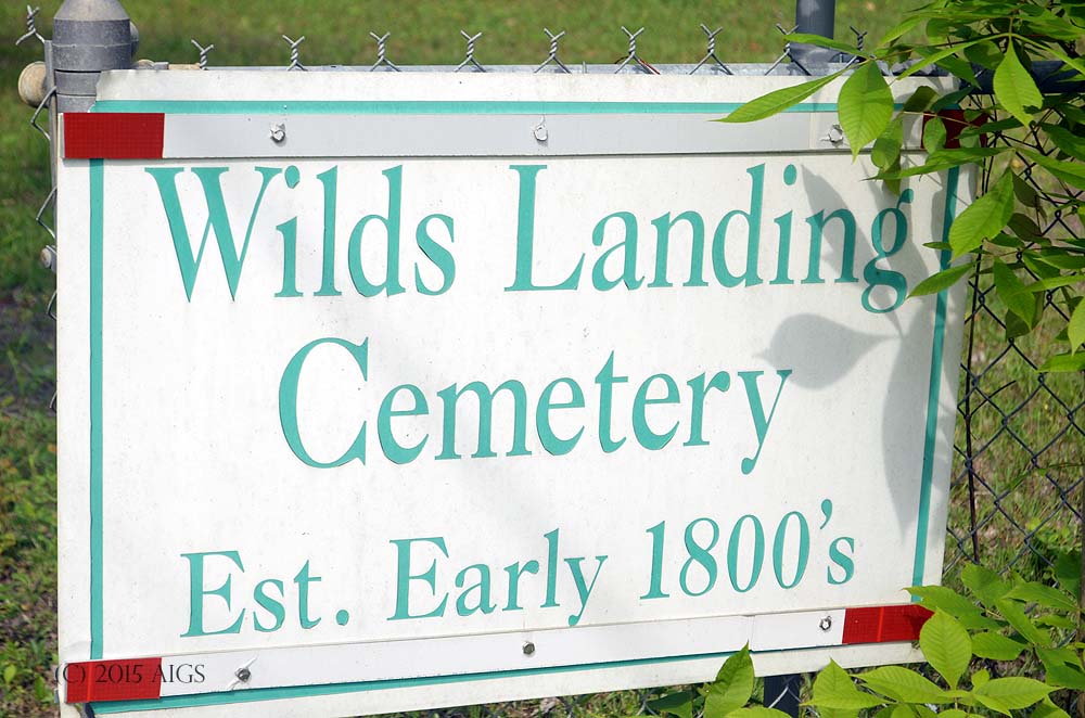
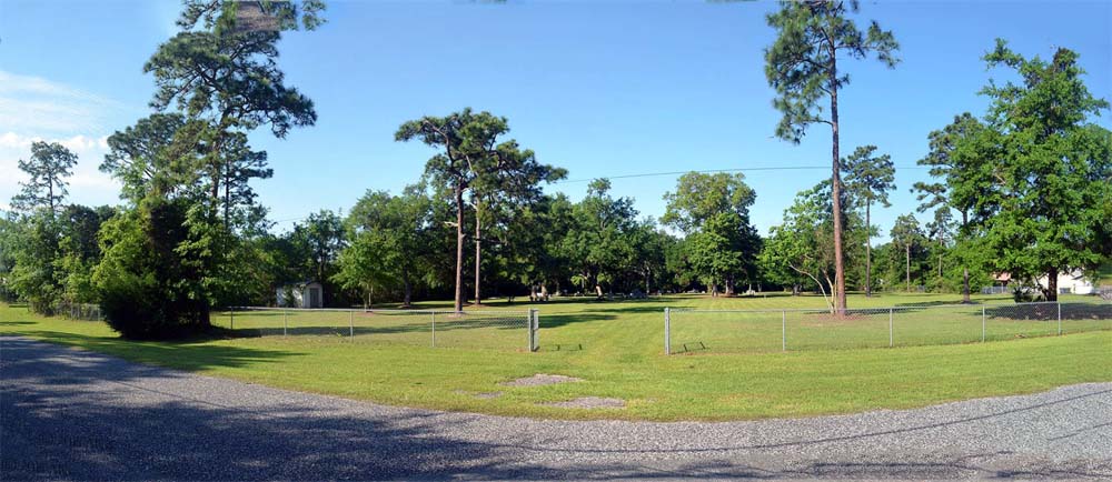
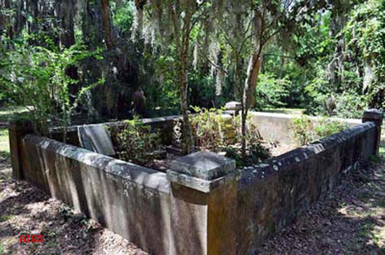
Kirkland Cemetery, also known as the Tomlinson Cemetery, Johnson/Tomlinson Cemetery, and McClean Cemetery, has three old stones, all of which are broken and five newer stones. There were probably more burials than the extant stones indicate. Some of the “old-timers” in the area think there were members of the Rowe family buried here including Peter Rowe. To reach Tomlinson Cemetery, from intersection of State Highway-108 and River Road, west of Callahan, proceed north on CR-121/SR-108A for 1.3 miles. Bear left at the fork, staying on CR-121 for 2 miles. Turn left (west) onto Tomlinson Road (unpaved) for 0.5 miles. Take 1st left, staying on Tomlinson Rd. for 0.2 miles. Turn right onto Lovett Ln3. Turn left onto Family Ln. Cemetery will be on left, in the woods, in 0.6 miles as Family lane makes a gentle right turn followed by a gentle left turn. Immediately after the gentle left you will see a small wooden pole, painted red, with white flagging (see Figure 18 in the survey report below). The cemetery is just past the pole. Kirkland Cemetery Location (Nassau County)3260 Family LaneHilliard, FL 32046 GPS Location: 30.616205, -82.024415 Kirkland Cemetery was inventoried in February of 1998 by Ken Sturges, and a second survey was made August 22, 2001 by Mary Nelson and Jean Mann. The most recent survey was conducted in May of 2013 by James Miller and Robert Frey. This survey includes a complete photo survey, GPS coordinates and a complete set of directions to the cemetery. See

Kirkland Cemetery Read More »

Thiede Cemetery

Thiede Cemetery

The Thiede Cemetery is located in Oyster Bay, a gated community at the end of Barnwell Road. Access is restricted and may be requested via Oyster Bay Harbor and Yacht Club at their website. The area is historically known as Heath’s Point. The cemetery is enclosed by a stone wall about 2 feet high. There are steps into the burial plots on both sides of the wall. An ornate floral spray of roses is carved into the Caroline Thiede monument. The cemetery is set on NE/SW direction. From the intersection of SR-200/A1A and O’Neil/Scott Rd. proceed west on SR-200 for 0.4 miles, turn right onto Barnwell Rd. Proceed 2.3 miles to the Oyster Bay Gate. Ask for directions to 96101 Park Place at the gatehouse. Thiede Cemetery Location (Nassau County)96101 Park PlaceFernandina Beach, FL 32034 USA GPS Location 30.653583, -81.511083 This inventory was made on June 24, 1995 by Mary Nelson and Jean Mann, and a second photogrpahic survey was completed June 8 2013 by Jim and Carol Miller The 8 June 2013 Survey of the Thiede Cemetery can be seen here. Property Appraisers PID 46-3N-28-5065-00HP-0000 Florida Master Site File ID NA00996 established circa 1884 Graves 3.

Thiede Cemetery Read More »

Swearingen Cemetery

The Swearingen Cemetery is identified in the WPA Veterans’ Graves Project of 1940/1941, but it has never been located or surveyed recently. Wayne Swearingen was born in Camden County GA. He moved to Nassau County Florida on Federal land he purchased between 1850 and 1857, some of which was granted for his services in the Florida Indian Wars (Seminole War). Following his death in 1874 he was buried near Kings Ferry in Nassau County Florida, probably on his Father’s original plantation about 2 1/2 miles from Kings Ferry. Jim Miller has studied the four cemetery locations near Kings Ferry and concluded we may never locate the actual grave of Wayne Swearingen However, his grave was identified by the Veterans’ Grave Registration project, and we do have documentation that he served as a Sergeant in the Florida Indian Wars, and that a veteran’s monument in his name was shipped to Kings Ferry for his grave “near” that location. Jim Miller’s study of the four cemeteries near Kings Ferry can be viewed here. The details of the Swearing Cemetery are included on on pages 5 through 8 of that work.

Swearingen Cemetery Read More »

Haggadon Cemetery

The Haggadon Cemetery is located in Crandall Florida on the Stuart Davis estate. Leaving the intersection of SR 200 (A1A) and Chester Road, proceed north on Chester Road 3/10 of a mile where you cross railroad tracks; go an additional 3 miles to Roses Bluff Road. Turn left on Roses Bluff and go 1.7 miles until pavement ends. Continue along the dirt road for 1.3 miles to a locked gate. Go down dirt (rough) track on the left alongside fence about 1/10 mile to cable locked across the dirt trail. Sign Posted Private Property. Go past locked cable ½ mile to home on Bells River. The lone grave is on the right hand side of the dirt road about 200 feet behind the house. The stone is broken into three pieces and worn making it difficult to read. Thomas N. Haggadon [sic] was a registered voter in the Kings Ferry precinct in December 1884 when he signed a petition solicited by Wm. T. Russell for a liquor license. The list was published in The Florida Mirror on January 17, 1885, and was printed in The Nassau County Genealogist, Volume IV #1. He was a veteran of the Civil War with Cpt Perry’s Co, FLA Light Artillery, CSA. Haggadon Cemetery Location (Nassau County)Stuart Davis EstateRoses Bluff, FL USA GPS Location: 30.695983, -81.591659 This cemetery was surveyed in February 1999 by Nancy and Ken Sturges.

Haggadon Cemetery Read More »

St Theresa’s Cemetery

St Theresa’s Cemetery is in Hilliard. One mile from the center of Hilliard business district off intersection of CR 108 and Mills Street. This cemetery is adjacent to the Oakwood Cemetery in Hilliard Florida. The cemetery is small and no attempt was made to number the graves. St Theresa’s Cemetery Location (Nassau County)37349 Ruby DriveHilliard, FL 32046 USA GPS Location: 30.700424, -81.918472 Inventory made by Charlene and Lavada Wilkes in May 1993. Verified by Kenneth Sturges, Nancy Sturges, Mary Nelson and Wanda Simpson in March 1998, with another independent survey by Lori Bragg.

St Theresa’s Cemetery Read More »

Springhill Cemetery

Springhill Cemetery is in Nassauville Florida. To reach it, from Highway A1A, at the O’Neal traffic light, turn (south) onto SR 107(Old Nassauville Road). Go 3.3 miles and Springhill Baptist Church and cemetery are on the right. The cemetery is to the left of the church, you can drive around the back to reach it. Springhill Cemetery Location (Nassau County)941017 Old Nassauville RoadFernandina Beach, FL 32034 USA GPS Location: 30.572601, -81.521604 This cemetery was inventoried in May 1993 by Jay Jenkins, and verified in February 1998 by Ken and Nancy Sturges. Florida Master Site File ID NA00995 established unknown graves 100.

Springhill Cemetery Read More »

Snowball Cemetery

Snowball Cemetery

Snowball Cemetery is in Yulee Florida. To reach it, from SR200, take Chester Road 4/10 mile to the intersection with Page’s Dairy Road. Turn left (west) on Page’s Dairy Road and continue 2.7 miles. Cemetery is on the left. At the time this inventory was made, only two tombstones continue to exist. Mr. Cliff Flood of Yulee told Mrs. McCabe there were Snowballs and Evatts buried in this cemetery. Snowball Cemetery Location (Nassau County)1851 Pages Dairy RoadYulee, FL 32097 USA GPS Location: 30.639441, -81.586941 This Inventory made in February 1994 by Shirley Johnson McCabe, with pictures and additional information supplied by Terrill Thompson. Additional information regarding the cemetery is contained in the published article by Pauline Roberts printed in 1977, The Family of Edwin Ruthben and Charlotte Marion Snowball.

Snowball Cemetery Read More »

Slawter Cemetery

The original location of this cemetery was on the left of SR 200 1.4 miles east of the junction of US 1/US 301 and State Road 200. In 1996, the Florida Department of Transportation decided to widen the road between Callahan and Yulee. The Department contacted the descendants of the Slawters and arranged to remove the remains to the Jones Cemetery on River Road west of Callahan. This was accomplished on May 28, 1996, and these graves appear in the Jones – Callahan survey with photographs. The cemetery was surveyed on 2 April 1993 by Connell Ward Jenkins and Shirley Johnson McCabe. Additional information provided by Kenneth Sturges on March 15, 1998. Slawter Cemetery Layout

Slawter Cemetery Read More »

Scroll to Top