Pensioners in Nassau County, 1884
List of pensioners of Nassau County for the year 1884 as published in the Florida Mirror on 8 March 1884.
Pensioners in Nassau County, 1884 Read More »
The Amelia Island Genealogical Society has collected 47,000 genealogical records for individuals who have lived in Nassau County Florida.

List of pensioners of Nassau County for the year 1884 as published in the Florida Mirror on 8 March 1884.
Pensioners in Nassau County, 1884 Read More »
Transcriptions of Nassau County marriages and deaths from the Florida Mirror for the year 1879.
1879 Marriages & Deaths from The Florida Mirror Read More »
This article comes from vol II:1 (Fall 1994) of the Nassau County Genealogist and features the names of baseball players of early Fernandina teams.
First Baseball Team in Fernandina Read More »
Nassau Democratic County Convention held at Callahan, Fla., on September 11, 1880, transcribed from the Florida Mirror, September 18, 1880.
Nassau County Democratic County Convention – 1880 Read More »
The following names appear on stained glass windows in St. Peter’s Episcopal Church in Fernandina Beach, Florida. The church was designed by Robert Sands Schuyler in the Gothic Revival style in 1884, destroyed by fire in 1892 and then rebuilt and enlarged.
Memorial Windows – St. Peter’s Episcopal Church Read More »
Marriage and Death notices from the Florida-Georgia News, Fernandina, Florida
and The Fernandina News, Fernandina, Florida for the years of 1938 and 1939.
Marriage & Death Notices – 1938-1939 Read More »
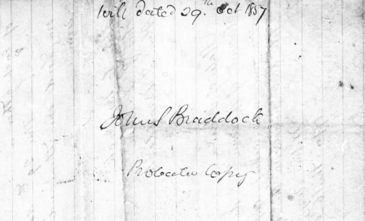
John Spicer Braddock wrote out his will on 29 Oct 1857 and had it witnessed by his sons Spicer C. Braddock and Alex. J. Braddock, and a third individual, Thos. J. DuBose. A copy of the will would be filed by Sarah in October of 1866 after the death of her husband in an attempt to probate the remaining property. She would use the will as part of her evidence in her Standing Interrogation of 1872 and hence this copy. The existing copy on file at the Nassau County Courthouse under their land records is similar, though they are not exact copies, the differences do not affect the bequeaths of the will, but instead reflect careless copying. It is likely the one on file in the land records is also a copy of the original. The original believed to be extant.
1857 Will of John Spicer Braddock, Sr. Read More »
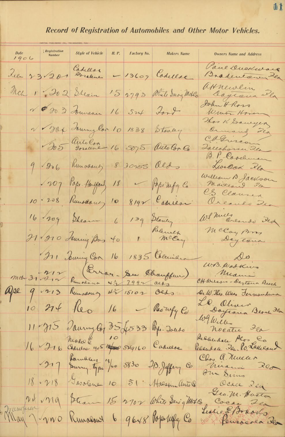
This dataset includes the first automobile registrations recorded by the Florida Department of State in Nassau County between 1905 and 1917. Each registration is recorded in a handwritten ledger and includes the registrant's name, address, and information about the vehicle, such as the manufacturer, style, horsepower, and factory number. The entries are dated and assigned a unique registration number, which was sent to the registrant on a certificate. Click on an image to see the original auto registration page your ancestor appears on.
Nassau County Florida Auto Registrations, 1905-1917 Read More »
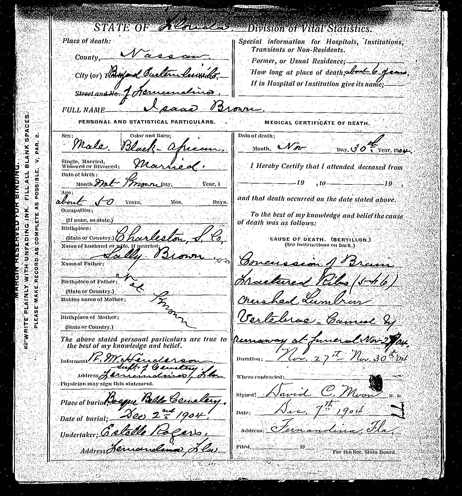
The records on this dataset consist of death certificates in which Nassau County was either the location of the death or burial. That’s an important distinction as not all of these individuals died within Nassau County. Please see the specifics for each record. Genealogists can find within these records the following information if known: name, sex, color, age, death date, death place, burial date, cemetery, birth date, birth place, residence, occupation, marital status, spouse’s name, father’s name, father’s birth place, mother’s name, mother’s birth place, death certificate number, and an image of the actual death certificate on file. Click on “more details” to see all the information for that individual. This additional information will appear in a popup (so make sure your not blocking popups). Click on the image link to view and/or download a larger image of the certificate. Microfilm of original records at the Florida Dept. of Health – Vital Statistics in Jacksonville, Florida. Florida. Department of Health. Bureau of Vital Statistics. Indexed by Amelia Island Genealogical Society....
Nassau County Death Certificates 1904-1939 Read More »
Records transcribed from the Nassau County Deed Book A which covered the years of 1840 to 1842. These records were subsequently published in The Nassau County Genealogist, vol. 5, p. 61-67.
Records from Nassau County Deed Book A – 1840-1842 Read More »