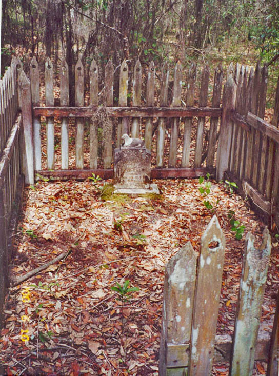
Online Records

The Amelia Island Genealogical Society has collected 47,000 genealogical records for individuals who have lived in Nassau County Florida.

Motes Cemetery

Motes Cemetery

This cemetery is near Baldwin Florida. To reach it from Callahan, take US 301 south to CR 119 at Bryceville, Go right (west) to CR 121. Turn left (south) and go about 1 1/4 miles to a dirt road on right. Turn right and go about 1/3 mile to the end. A residence is on right. The cemetery is laid out facing east with the gate on the east side. For the latest 2014 survey, the cemetery was divided into in XY grid with four divisions, A1 (100 X 100ft), A2 (50 X 100ft, B1 (100 X 50ft) and B2 (50 X 50ft). Most of the burials are in Division A1, but all grave locations are identified by Division and XY location. There is one fenced plot with four graves, only the grave of Eliza Grand has a full headstone with name and date, and this fenced area has been arbitrarily named the Grand plot. Motes Cemetery Location (Nassau County)Glidden LaneBaldwin , FL USA GPS Location 30.394734, -82.038106 The cemetery was inventoried on December 4, 1998 by Jan C. Plemmons and Jan Warren, following an earlier survey by Yuvonne Phillips Johnson in 1986 which identified two other graves not now identifiable. Lori Bragg also did a survey. The latest photographic survey was completed in July 2014 by Danny Mallard. Motes Cemetery Layout

Motes Cemetery Read More »

Mill Creek Primitive Baptist Church Cemetery

This cemetery is south of Hilliard. To reach it from Hilliard, take St. George Road (CR121) and proceed south for 9 miles. Turn right and go 2/10 mile to the cemetery on right. Graves were inventoried in order, but no layout exists for the cemetery. Alternatively, go the junction of CR 121 and CR 108, south west of Hilliard FL. Follow Carrol Corner Rd. 0.2 miles and the cemetery is on the right. Mill Creek Primitive Baptist Church Cemetery Location (Nassau County)2936 Mill Creek Rd.Hilliard, FL GPS Location 30.606267, -82.001412 The cemetery was inventoried December 4, 1998, by Jan C. Plemmons and Jan Warren. Nassau County Appraiser PID 10-2N-23-0000-0010-0000

Mill Creek Primitive Baptist Church Cemetery Read More »

Martin Cemetery

This cemetery is in Sandhill Florida. To reach it, go north on US 17 from Yulee, turn left onto CR 108, go over the I-95 overpass, continue past Owens Road, through Evergreen to the Sandhill community. Turn right onto a small dirt road 4/10 mile before Lessie Road. Go 1/10 miles down the dirt road and you will find the cemetery tucked in the middle of a small stand of old oak trees surrounded by pine trees. Martin Cemetery Location (Nassau County)04 mile before Leslie Rd on CR 108FL 32097 USA GPS Location 30.700505, -81.769691 The cemetery is surrounded with fence wire and can be opened on the southwest corner. There are 17 unmarked burial sites in the cemetery. This cemetery was inventoried in March 1998 by Kenneth Sturges.

Martin Cemetery Read More »

Grave of Caroline Eveline Hightower

Laodicea Primitive Baptist Church Cemetery

The Laodicea Primitive Baptist Church is on the CCA – Thomas Creek Tract. Some sources place this cemetery about 9 miles south of Callahan off US 1 near Thomas Creek, but we have no definite confirmation of the cemetery location. According to information found in Volume 3, #2 of the Jacksonville Genealogical Society Quarterly, published in 1975, this was once a large cemetery which was abandoned in 1955. The Laodicea Primitive Baptist Church once stood on this site. The only Surviving grave that can be identified is that of Caroline E. Hightower. According to Linda Dyal Johns, Her great-grandfather, John Zacharias Hightower was buried next to the grave of his wife Caroline Eveline (Nettles) Hightower in 1928. Caroline Hightower’s birth and death dates are listed in the cemetery database. This was once a thriving church and evidence of other graves exist, but no markers are in evidence. The photograph below is also courtesy of Linda Dyal Johns. Laodicea Primitive Baptist Church Cemetery Location (Nassau County)9 miles south of Callahan on US 1 or US 301FL USA GPS Location: 30.486432,-81.786432 (Points to the Thomas Creek Tract, not the cemetery itself) Note about the exact location of Laodicea Primitive Baptist Church Cemetery The above location is combined from various sources, none of which are precise enough for us to provide even a general idea of the location. Instrumental in the confusion is the fact that the Thomas Creek Tract is less than 5 miles from Callahan, and traveling 9 miles would remove

Laodicea Primitive Baptist Church Cemetery Read More »

Live Oak Cemetery

The Live Oak Cemetery, also known as the Dyal Station Cemetery, is located near Callahan Florida. To reach it from Callahan, at the intersection of SR15/US301N and A1A/301S, go north on SR 15 past the Nassau County Fairgrounds and turn left on Dyal Road and go about one mile. Just before the railroad tracks, turn left onto dirt road. Turn left on Congregation Lane. The church and the cemetery are on the right. The Live Oak Baptist Church was established in 1845 in a one-room log cabin. Later, the church membership met in a schoolhouse. In 1903, B. G. Dyal deeded two acres of land to the congregation where the first permanent church was built. Additional land was donated by Container Corporation of America and William Cook. Services each Sunday were not begun until February 1938. In September 1995, the original sanctuary was moved and the foundation was poured for a new sanctuary. The first burials in the cemetery were in 1885. The Live Oak Cemetery contained 554 graves when it was surveyed in 2001. The cemetery is organized by row then grave location. So, the fourth grave in row 5 would be identified in the database as Row 5, Grave 4. Live Oak Cemetery Location (Nassau County)36178 Congregation LaneCallahan, FL 32011 USA GPS Location 30.617972, -81.866052 Inventory begun on January 31, 2001, by Mary Nelson, Karen Fink, Barbara Swearingen and Jean Mann; interrupted due to rain. Completed on May 17, 2001, by Jean Mann Florida Master Site File ID

Live Oak Cemetery Read More »

Little Cemetery

This Cemetery is located in Sec. 23 Township 2 North Range 23 East Near Callahan. The location information was not provided by the survey team. Grave numbers are from first to last, with row not recorded. The GPS data is take from the center of the Township and Range data so it may not be precise. Little Cemetery Location (Nassau County)River RoadCallahan, FL GPS Location 30.5825705, -81.9844753 (not precise) AIGS members provided the survey, and they were combined with a separate survey by Lori Bragg. survey dates were not recorded either case.

Little Cemetery Read More »

Kings Ferry Cemetery

Kings Ferry Cemetery

To reach Kings Ferry Cemetery, also known as the Haddock Cemetery, go North on County Road A121 off CR 108 between Hilliard and US17. Go approximately 6 miles. On the left is a dirt road marked with a sign, “King’s Ferry Cemetery”. Turn left, the cemetery is on the right about 1/2 mile. -OR- From the intersection in Kings’ Ferry off CR A121 and Lessie Road, go south for 1.6 miles, turn right on a dirt road marked with the sign, “King’s Ferry Cemetery.” The cemetery is on the right about 1/2 mile. Many of the plots are surrounded by ornate wrought iron fences that are in rusted condition. In 1996, the entire cemetery was burned, possibly to get rid of undergrowth as the easiest method of clearing. This is one of the oldest cemeteries in the county, circa 1700. Kings Ferry Cemetery Location (Nassau County)Kings Ferry, FL USA GPS Location 30.760971, -81.829698 Inventories February 17, 1996 by Mary Nelson, Marguerite Frosher, and Jean Mann. Also inventoried circa 1997 by Lori Bragg (USGenWeb). Inventoried in 1956 by LDS Church. (Published ’56, surveyed ’53) Surveyed for veterans in 1941 (WPA)

Kings Ferry Cemetery Read More »

Keen Cemetery

The Keen Cemetery is located near Crawford Florida. To reach it, from Callahan, go south on SR200/US301 for about five miles. Go left on Thomas Creek Road for 2.8 miles, proceeding in a southeasterly direction. Turn right on Ratliff. Go over the railroad tracks. Turn right on Keen Cemetery Road. Keen Cemetery Location Keen Cemetery (Nassau County)Keen Cemetery RoadCrawford, FL 32011 USA A flag pole in the cemetery has the following inscription: “Eagle Project – Justin Dyal, BSA Troop 55, 4-9-88.” The Cemetery was inventoried on May 16, 1998 by Ken and Nancy Sturges, Wanda Simpson and Mary Nelson.

Keen Cemetery Read More »

Jones-Jacobs Cemetery

Jones-Jacobs Cemetery, is in Evergreen Florida, also known as Elmore Wilds Cemetery, and may also have been known as Evergreen Cemetery. Go north on US 17 to CR 108. Turn left, proceed to first paved road on left (Sandhill Dump), turn left. There is a fork in the road at about 600ft, take the right fork to the locked gate. About 8/10 mile from CR 108 are two cemeteries here, Jones-Jacobs and Wilder-Wilds. The Wilder-Wilds data is reported separately. Jones-Jacobs Cemetery Location (Nassau County)Evergreen, FL GPS Location 30.686872, -81.724684 This cemetery was inventoried in March 1998 by Kenneth Sturges. Jones-Jacobs Cemetery was surveyed in 1941 as part of the WPA Veterans’ Grave Registration Project, identifying one WW1 veteran Pfc. James Lafayette Albertie. It was referenced as Evergreen Cemetery. It was photographed in 2015 by Jim Miller.

Jones-Jacobs Cemetery Read More »

Jones Cemetery - Callahan

Jones Cemetery – Callahan

To reach this beautifully kept cemetery, Turn left off SR 200 at Callahan Florida going north one block on US 1/301.t Turn left on on on Brandies Avenue (CR 108) and at the railroad track, keep to your right following River Road (CR108). Go 1.5 miles, and turn right on Jones Cemetery Road. The cemetery is about 100 yards down the road, with the main entrance on the right. This is a very old cemetery, with 1,550 graves in the oldest (Eastern) section and about 420 graves on the west side. There are twelve Confederate Civil War Veterans buried here, all in the oldest area, section 1. The oldest person buried here is John Jones, 1800 – 1873 closely followed by Anna O’Donald 1800-1880. The cemetery contains three graves from the O’Donald Cemetery which were re-located here prior to 1956. These graves can be found in Section 1, row 30. The numbering system of the sections and rows follows that used by the Jones Cemetery association. Section 1 is numbered in rows 1 to 30 the remaining sections are alphabetical. In the alphabetical sections, “A” rows were inserted between plot rows which are 20 feet apart. The grave numbering begins at the flagpole in the center of the cemetery with sections 1, 5 and 6 going east, and sections 2,3 and 4 going west. Additional detail is shown in the grave layout . Each grave is identified by a number/letter series. The first number is the section, the second letter

Jones Cemetery – Callahan Read More »

Scroll to Top