Online Records

The Amelia Island Genealogical Society has collected 47,000 genealogical records for individuals who have lived in Nassau County Florida.

Springhill Cemetery

Springhill Cemetery is in Nassauville Florida. To reach it, from Highway A1A, at the O’Neal traffic light, turn (south) onto SR 107(Old Nassauville Road). Go 3.3 miles and Springhill Baptist Church and cemetery are on the right. The cemetery is to the left of the church, you can drive around the back to reach it. Springhill Cemetery Location (Nassau County)941017 Old Nassauville RoadFernandina Beach, FL 32034 USA GPS Location: 30.572601, -81.521604 This cemetery was inventoried in May 1993 by Jay Jenkins, and verified in February 1998 by Ken and Nancy Sturges. Florida Master Site File ID NA00995 established unknown graves 100.

Springhill Cemetery Read More »

Snowball Cemetery

Snowball Cemetery

Snowball Cemetery is in Yulee Florida. To reach it, from SR200, take Chester Road 4/10 mile to the intersection with Page’s Dairy Road. Turn left (west) on Page’s Dairy Road and continue 2.7 miles. Cemetery is on the left. At the time this inventory was made, only two tombstones continue to exist. Mr. Cliff Flood of Yulee told Mrs. McCabe there were Snowballs and Evatts buried in this cemetery. Snowball Cemetery Location (Nassau County)1851 Pages Dairy RoadYulee, FL 32097 USA GPS Location: 30.639441, -81.586941 This Inventory made in February 1994 by Shirley Johnson McCabe, with pictures and additional information supplied by Terrill Thompson. Additional information regarding the cemetery is contained in the published article by Pauline Roberts printed in 1977, The Family of Edwin Ruthben and Charlotte Marion Snowball.

Snowball Cemetery Read More »

Slawter Cemetery

The original location of this cemetery was on the left of SR 200 1.4 miles east of the junction of US 1/US 301 and State Road 200. In 1996, the Florida Department of Transportation decided to widen the road between Callahan and Yulee. The Department contacted the descendants of the Slawters and arranged to remove the remains to the Jones Cemetery on River Road west of Callahan. This was accomplished on May 28, 1996, and these graves appear in the Jones – Callahan survey with photographs. The cemetery was surveyed on 2 April 1993 by Connell Ward Jenkins and Shirley Johnson McCabe. Additional information provided by Kenneth Sturges on March 15, 1998. Slawter Cemetery Layout

Slawter Cemetery Read More »

Russell Family Cemetery sign

Russell Family Cemetery

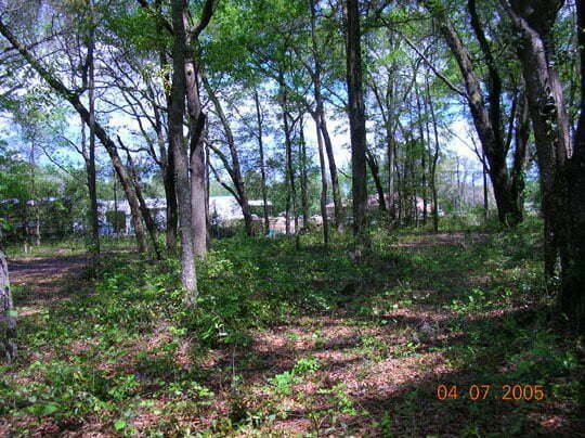
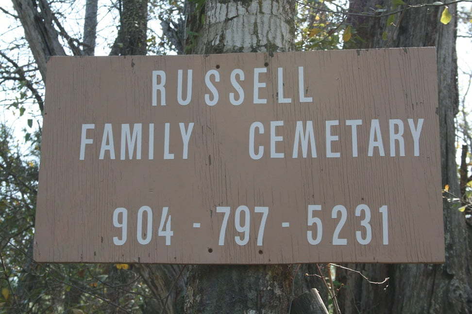
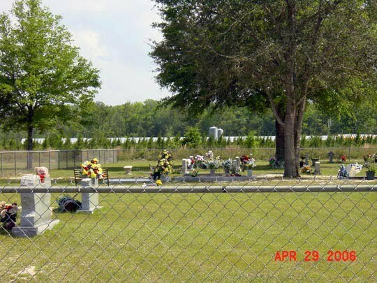
To reach the Russell Family Cemetery, also known as the Russell Cemetery, from the intersection of SR-200/A1A & US-17 go north 2.61-miles to a gravel road on the left. Turn west onto the gravel road, cross the railroad tracks and take the right fork, timber road 56, to the locked Rayonier Corporation gate. Proceed along timber road RD-56 for 1.07-miles, crossing under the power line at 0.7-miles. You will come to an intersection with two roads on the left, one on the right. Turn right (north) on the dirt road, proceeding to a large oak tree; follow the tracks to the right (east) to the cemetery. It is believed that the family home was located north west of the oak tree. The cemetery is on privately owned timber land managed by Rayonier Corportation, and access is available only by contacting Russell family representative David E. White at (386) 292-0955 or through Rayonier directly. The cemetery is within a fenced area approximately 100 X 70 feet, and the burial area seems limited to a 60 X 70 ft area which was surveyed. GPS coordinates of the survey area are included in the attached report. Russell Family Cemetery Location (Nassau County)Timberland, US Highway 17Yulee, FL 32097 USA GPS Location: 30.6589166, -81.647528 Twelve graves were located, all marked with headstones or crosses, with two additional depressions located which might also be graves. The full survey can be viewed by following this link: Russell Family Cemetery survey report prepared by Jim Miller. The survey

Russell Family Cemetery Read More »

River Road Baptist Church Cemetery

River Road Baptist Church Cemetery

River Road Baptist Church Cemetery is in Hilliard. Go south from the center of Hilliard on CR 108 / CR 121 about 11.75 miles. The church shown in the attached photograph will be visible. Immediately behind the River Road Baptist Church across from the fire department is the cemetery. River Road Baptist Church Cemetery Location (Nassau County)21067 County Road 121Hilliard, FL 32046 USA GPS Location: 30.561013, -81.990801 This inventory was done by Kenneth Sturges in March 1998. River Road Baptist Church Cemetery Photographs Pictures are courtesy of Jean Mizell.

River Road Baptist Church Cemetery Read More »

Reynolds Cemetery

The cemetery is located in the Rayonier Management Area – Wildwood Road, Nassau County, Florida. No public access. Contact Smurfit-Stone or Rayonier Corporation for information regarding access. Reynolds Cemetery Location (Nassau County)Wildwood RoadYulee, FL 32097 USA GPS Location 30.622805, -81.666000 This GPS location and map only take you to the intersection of Muddy Trail with Wildwood Road, not to the Cemetery. This is survey was made in May 1993 by Ann Duff, Shirley McCabe, and Joan Johnson. Photos courtesy Marie Wingate, taken in 2013. Marie reports that family members who had visited the site before noted unmarked graves, via visible depressions.

Reynolds Cemetery Read More »

Pringle Cemetery

The Pringle Cemetery, also known as the Kinard Cemetery, is located near Bryceville Florida. From the intersection of US 90 and CR 121 in Baldwin, turn north onto CR 121 and go ten miles to Kinard Road. Turn onto this dirt road and go one mile to dead end with locked gate on the right. There is no sign. A woven wire fence encloses a chain link fence surrounding this cemetery. Pringle Cemetery Location (Nassau County)Kinard RoadBryceville, FL 32009 USA GPS Location: 30.445900, -82.026627 This cemetery was surveyed in August 1996 by Grady Hagan, J. W. Conner and Ethel Holton and verified in Spring 1998 by Kenneth Sturges.

Pringle Cemetery Read More »

Pigeon Creek Cemetery

Pigeon Creek Cemetery

This cemetery is in Boulogne, Florida. To reach it, take US 301 north from Callahan and through Hilliard. Just before the St. Marys River and crossing into Georgia, turn right on Lake Hampton Road. Go .4 mile to Pigeon Creek Road. Turn right on this dirt road and follow to the church on the right and the cemetery on the left. Pigeon Creek Primitive Baptist Church was Florida’s only known Protestant church when the territory became a part of the United States. The church was organized on 7 January 1821 by Isom Peacock and Fleming Bates. Other founding church members were Britton Knight, Edward Dixon, Thomas Prevatt, J. E. R. Prevatt, Chloe Knight, Polley Knight, Sarah Dixon, Polley Prevatt, Susannah Prevatt, Susannah Dixon and Ellender Cread. Bates was the first pastor of the church. In 1822, a man named Peter was the first black member of the church making this the first integrated church in Florida. A concrete block church building replaced the original hard pine board and batten building in 1957. The cemetery is laid out facing east with the gate on the west side. The inventory was made in two parts B north half and south half starting on the easternmost row. The north half was begun on the north end of the row working towards the middle; the south half was begun on the south end of the row working towards the middle. Inscription are copies exactly as they appear on the markers. Rows 2 and 3

Pigeon Creek Cemetery Read More »

Owens Cemetery

Owens Cemetery

The Owens Cemetery is in Evergreen Florida, located on the private property of L. L. Owens approximately ½ mile from the southwestern terminus of Owens Cutoff Road at Nassau County Highway 108. When driving northeast, CR 108 takes a right turn, continue straight ahead, across the cattle guard, and follow the ruts to the Owens farmhouse. The cemetery is located on a small rise beneath a canopy of large oak trees with many old azaleas and camellias. A chain link fence surrounds the sixty foot square cemetery. Owens Cemetery Location (Nassau County)Evergreen, FL USA The Owens Cemetery was inventoried by Kenneth Sturges in February 1998, with a second inventory by Linda Davis in April 2010. Florida Master Site File ID NA00994 established circa 1884, graves 10. Owens Cemetery Photograph

Owens Cemetery Read More »

Old Still Cemetery

Old Still Cemetery is in Hilliard Florida and has gone by many names including the Davis/Blake Cemetery for the preponderance of Davis and Blake graves. From Hilliard, take County Road 108 east to FAA Facility. This is the intersection of CR108 and CR15A. Go north on CR15A for 1.6 miles. The Latter Day Saint Church is on the left. Just beyond the church is a dirt road, Oak Grove Drive, turn left. Follow the dirt road to the end (.3 mi) and you will come to the cemetery. The cemetery is surrounded by a chain link fence and is reasonably well maintained. A smaller fenced area outside and north of the cemetery encloses one grave. This cemetery is also known as East Still Cemetery which is the major cemetery and West Still Cemetery which contains the single grave of Jefferson Murrhee. Eula Davis (Mrs. Upton) lived in an old farmhouse on CR15A. She is the daughter of Carrie Adelia Blake and Henry Murrhee and the granddaughter of John Blake who came from Boston, Massachusetts to the Hilliard area. She says that he was one of the founders of Hilliard. Mrs. Davis is 88 (b. c1908) and said that when she was a little girl, relatives told her that there used to be graves outside the fenced area, but any markers had long ago disappeared. The small fenced area to the north of the cemetery encloses the grave of Mrs. Davis’ grandfather, Jefferson Murrhee (pronounced Marie). Request information or access to

Old Still Cemetery Read More »

Scroll to Top